|
Although I am going to discuss
here about Thrace within Turkey, I also would like to give a
description of the proper Thrace as described by the ancient authors.
Because ancient Thrace covers much larger area including territories
covered by today's Balkan and Mediterranean countries, such as
Macedonia, Greece, Bulgaria and Turkey.
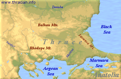
Borders of Thrace
Thrace, in broad sense, roughly covers the area
from Black Sea in the east to the river Vardar in the west and from the
river Danube in the north to the Aegean Sea in the south. Thrace is
bound by Pontus Euxinus (Black Sea), Bosporos Thrakios (Bosphorus
Strait), the Propontis (Marmara Sea), in the east, and by the
rivers Istros (Danube) and Axios (Vardar river) in the north and west,
by the Aegeus (Aegean Sea) and Dardanelles (Hellespont
Strait). Just on the heart of this ancient region is Edirne (ancient
Hadrianopolis).
Sometime, the northern border is considered to be the Haimos (Balkan
mountains) and the western border as to be the river Strymon (Struma
river). Strabon in his book Geography explains
"In the area as far as Strymon river live
Macedons, Paions and some tribes of the Thracians, beyond this point as
far as Haimos mountains except the coastal area lives the Thracians".
Strabo also says "when the Romans extended
and divided the territories in Macedonia into four portions, the
western border of Thrace became the river Hebros (Maritsa=Meric)".
Later when Thrace became a province, the western border was decided to
be the river Nestos (Mesta=Karasu).
The fertile and rich area to
the east of Thrace which is bound by Pontus Euxinus in the north, by
Bosporos Thrakios on the east, by the Propontis Sea on the south and by
the line stretching from the town Salmydessus on the coast of the
Pontus Euxinus to the town Perinthus on the coast of the Propontis sea,
is called the Delta. This was well explained in the book of Anabasis
(Return of the ten thousand) by Xenophon. On the southern tip of the
Peninsula was the Chersonessos Thrakios (Chersonessos of Thrace)
(Callipoli=Gelibolu Peninsula), which was surrounded by the Dardanelles
and the Propontis and by the Bay of Melas (Saros) on the west.
Physical Features
Mountains and Plains
Thrace has mountains to the north and south and large plains in between
them. Principal heights of the region are the Haimos (Balkan) mountains
on the north and Rhodope mountains on the south. Between these mountain
chains lies the large plain of Ergene. The mountain chain that runs
along the Pontus Euxinus whose ancient name is unknown is called
Istranca, and was known to the Romans as Mount Asticus after the
Thracian tribe of Asts who settled this area. On the south, along the
Propontis Sea was the Ganos mountain which was probably known to the
ancients as Hieron Oros that means Sacred Mountain.
Climate
The interiors of Thrace had a very cold climate.
Xenophon mentions with all the details, in his book Anabasis, the cold
day he and his army spent under a heavy snowstorm in the plain of Thyn
in the neighborhood of the town Perinthus.
"There was deep snow, and cold so intense
that the water brought in for dinner and the wine within the jars
froze; and many of the Hellenes had their noses and ears frost-bitten.
Now they came to understand why the Thracians wear fox-skin caps on
their heads and about their ears; and why, on the same principle, they
are frocked not only about the chest and bust but so as to cover the
loins and thighs as well; and why on horseback they envelop themselves
in long shawls which reach down to the feet, instead of the ordinary
short rider's cloak".
Ancient writers describe Thrace as open to the
northern winds, covered by a dense forest and not suitable for human
inhabitation. Thrace was covered by the forest on the mountains to the
north and south and by the steppes in the large flat plain.
Rivers
The
main river in Thrace was Istros (Danuvios=Danube) which flew from the
interiors of Europe into the Pontus Euxinus. There were many other
streams flowing in the north-south direction, pouring their waters into
the Istros river, To name these smaller rivers, from west to east,
Margos (Morava), Timacos (Timoka), Almos (Lom), Ciabros (Cibrica),
Augusta (Ogosta), Oskios (Oeskos=Iskar), Utus (Vit),Asamos
(Osam),Athyris (Iteros=Jantra). Further east, Aksios (Vardar) fed by
the waters of smaller streams of Astibos (Bregalnica), and Erigon
(Cerna), east and northeast of Vardar are Strymon (Struma) and Nestos
(Mesta) rivers.
In the south, and middle of the region ran the Hebros (Maritsa=Meric)
river to which the streams of Tonzos (Tunca), Ardeskos (Arda) and
Agrianes (Ergines=Ergene) joined. Agrianes had also smaller streams
joining it, Arzos (Corlu Stream), Tearos and Kontadestos. There were
also Apsinthos (Derbent), Melas which ran into the bay of Melas whose
name came from the river, Athyra (Cekmece) which flew into the
Propontis Sea, and both rivers of Cydaris (Alibey) and Barbyses
(Kagithane) flew into the Golden Horn in Istanbul.
In the Chersonessos (Callipolis=Galliopli) region was the Aigos
Potamois stream that emptied its waters into the Dardanelles
(Hellespont). Near this Aigos Potamois was the place where the decisive
naval battle between the Athenians and Spartans took place in 405
BCE.
Lakes
Thrace
is not rich in lakes. There are some lakes but not of great size. In
the eastern half are Phileitinios (Delcius=Terkos) near Istanbul, and
Stentoris at the mouth of the river Hebros. In fact , Stentoris was a
lagoon formed by Hebros, and Herodotus mentions of Stentoris as a
lake.
|